
Voyages sur mesure à Faroe Islands
Eighteen islands between Iceland and Norway, mostly green.
Qu'est-ce qu'un voyage sur mesure à Faroe Islands?
Faroe Islands' essential shots: Sørvágsvatn lake-above-the-ocean viewpoint (8 km hike, DKK 50 farm access, 2 p.m.–6 p.m. light), Gásadalur waterfall village (Mulafossur from the cliff edge), and puffin season at Mykines Island (May–August, ferry from Sørvágur). Fly into Vágar (FAE) via Copenhagen or London. Best season: May–September (greenest, puffins, longest days). The weather changes hourly — bring waterproof layers and accept that conditions will change mid-hike.
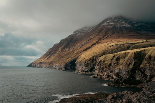
The Faroe Islands (Faroese: Føroyar, 'the Sheep Islands') is an archipelago of 18 volcanic islands in the North Atlantic Ocean, equidistant between Norway, Iceland, and Scotland — 50,000 people on 1,399 km². A self-governing territory of Denmark since 1948, the Faroese speak their own North Germanic language (Faroese, descended from Old Norse, mutually unintelligible with modern Danish), maintain their own government and flag, and have voted for independence in non-binding referenda (most recently 2023). The landscape is characterised by basalt cliffs rising 200–400 m from the sea, green-topped hills grazed by 70,000 sheep (more than the human population), turf-roofed churches, and near-constant Atlantic weather — the islands receive 250+ days of rain per year but the humidity creates a luminous quality to the light on clear days that photographers describe as unique in Europe.
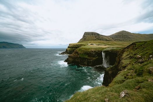
The most photographed location in the Faroe Islands is Sørvágsvatn (also called Sørvágsvatn or Leitisvatn — 'the lake above the ocean'): a lake on the island of Vágar that appears from a specific viewpoint on the southern cliff to be elevated 100 metres above the Atlantic, with waterfalls pouring directly from the lake into the sea. The optical illusion is a result of the cliff perspective — the lake surface is actually only 30 m above sea level, but the cliff drops 100 m below the lake edge so that the lake appears to float in the sky above the ocean. The hike to the viewpoint (from Miðvágur or Bøur village, 8 km round-trip, 2.5 hours, the viewpoint only accessible via a private farm — access fee DKK 50–100) is one of the most rewarding viewpoint hikes in Northern Europe. The waterfall Bøsdalafossur (the outlet waterfall from the lake, dropping 30 m from the lake edge into the Atlantic) is also visible from this position.
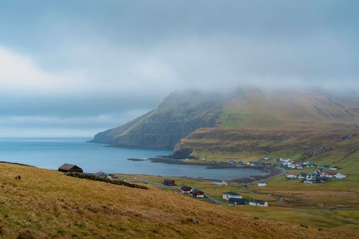
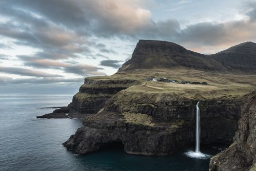
The village of Gásadalur: until 2004, the village (18 inhabitants) had no road connection — the only access was by helicopter or a 2-hour mountain pass walk. The Gásadalafoss waterfall plunges from the village cliff directly into the North Atlantic in a single 50-m drop visible from the sea. Mulafossur waterfall (same waterfall, same village, from the land-side perspective): the green turf-roofed houses of Gásadalur sit above the cliff, the waterfall beside them, the Tindhólmur sea stack (a 262-m basalt sea stack with five summits visible from the village) across the bay. The image of the waterfall with the turf-roofed village is the most published Faroe Islands photograph.
Quelle est la meilleure période pour visiter Faroe Islands?
Nos mois recommandés sont May–September. Voici une vue mensuelle avec des conseils de planification.
Meilleures expériences à Faroe Islands
Des moments sélectionnés par nos agences locales. Chaque voyage inclut une sélection de ces expériences — ou quelque chose de mieux.
Itinéraires types
Deux points de départ — votre vrai itinéraire est sur mesure. Nous construisons à partir de là.
7 jours classique
- 1Jour 1: Arrival Vágar & SørvágsvatnFly into Vágar Airport (FAE) — Atlantic Airways from Copenhagen (2 hours, daily), London Heathrow (2.5 hours, 3×/week), or Edinburgh (2 hours, seasonal). The Faroes have no high-speed road network — hire a car at the airport (necessary, no public transit coverage of the key sites, approximately USD 60–80/day). Drive 15 minutes to Miðvágur village for the Sørvágsvatn viewpoint hike (DKK 50–100 access fee, paid at the farm gate 1 km from Miðvágur). The 4-km walk to the viewpoint takes 50 minutes — the correct viewpoint (the 'lake above the ocean' optical illusion) is a flat rock shelf on the southern cliff edge at approximately 130 m elevation, looking north across the lake with the Atlantic below. Best light for photography: 2–6 p.m. on clear days (the western Atlantic light side-illuminates the cliff). Accommodation in Tórshavn (the capital, 50 km northeast from Vágar Airport via the sub-sea tunnel, DKK 160 toll).
- 2Jour 2: Tórshavn & TinganesTórshavn (population 22,000, the smallest capital city in the world by population in a fully self-governing territory): the old town Tinganes (the peninsula where the Althing parliament has met since the Viking age, 825 CE — one of the oldest continuous parliamentary sites in the world). The turf-roofed historical government buildings (18th–19th century, still occupied as government offices) crowd the narrow peninsula lanes. The Faroese National Museum (Hoyvík, DKK 100, Tues–Sun 10 a.m.–5 p.m.): the Enniberg seal-hunting boat (the traditional Faroese wooden rowing boat used for seal hunting and pilot whale drives), the traditional Faroese costumes, and the pre-Christian Norse religious objects. The Smyril (the old wooden government pilot whale monitoring boat in the harbour). Dinner at Barbara Fish House (Gongin, Tórshavn, the best restaurant in the Faroe Islands for Faroese fish: guillemot liver, fermented lamb, and fresh cod — USD 60–80, reservation required).
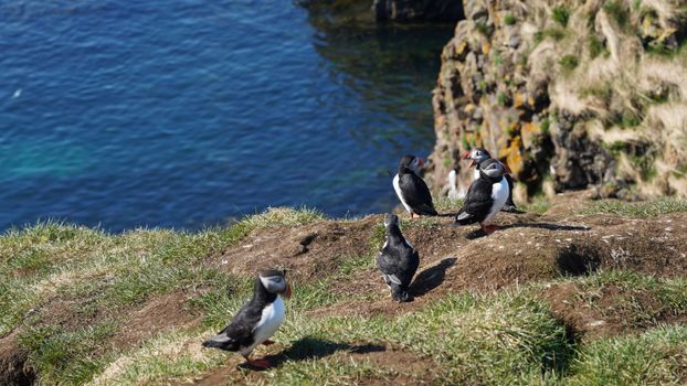
- 3Jour 3: Mykines Island — PuffinsFerry from Sørvágur ferry dock (Mykines Ferry, DKK 240 round-trip, departs 10 a.m. and 1 p.m. in summer, 45-minute crossing — the ferry is frequently cancelled in bad weather, particularly September–April). Mykines island (population 10 permanent residents, declining from 170 in 1965): the westernmost of the Faroe Islands, a 4.5-km-long basalt island with near-vertical Atlantic cliffs. The Atlantic puffin (Fratercula arctica) breeding colony on Mykines: May–August, approximately 15,000 puffin pairs nest in burrows on the grassy cliffs. The puffins stand 1–2 m from the path on the cliff edge above the sea — the most accessible large puffin colony in the North Atlantic. The Mykinesholmur lighthouse at the western tip (connected by a rope bridge over the 100-m gap, DKK 100 additional access fee): the gannet colony on the stack below the bridge.
- 4Jour 4: Gásadalur & Mulafossur WaterfallDrive to Bøur village (15 km from Sørvágur, the 2004 road tunnel replaced the mountain path): Bøur is the village below Gásadalur with the best view of Tindhólmur (the 262-m sea stack with five distinct summit peaks — the most dramatic sea stack in the Faroes). The short walk from Bøur to the cliff edge (15 minutes, free): the Tindhólmur reflected in the bay below. Continue through the tunnel to Gásadalur (2.8 km road, the village inaccessible until 2004): the 18 inhabitants, the old stone church, the path to the cliff edge where Mulafossur waterfall drops 50 m directly into the Atlantic. The viewpoint (5-minute walk from the village): the waterfall in the foreground, the turf-roofed houses above it, Tindhólmur across the bay. The best light is morning or evening — midday sun in summer (May–August) creates flat light on the falls. Return to Tórshavn via Sørvágur.
- 5Jour 5: Eiðisvatn & Eiði VillageDrive north from Tórshavn to the island of Eysturoy via the bridge (the only bridge connecting two Faroe islands, visible from the undersea passage): Eiðisvatn lake and Eiði village (the northern tip of Eysturoy). The Risin og Kellingin (the Giant and the Witch): two sea stacks north of Eiði visible from the road. According to Faroese legend, Iceland sent the giant (64 m) and the witch (68 m) to drag the Faroe Islands back to Iceland — they were turned to stone by the rising sun before completing the task. The Eiðisvatn lake (a small coastal lake where the cliff meets the sea on two sides): similar geometry to Sørvágsvatn but smaller and less crowded. The Enniberg cliff (the second-highest cliff in Europe, 754 m vertical drop directly into the sea, visible by boat tour from Klaksvík or by the ridge hike).
- 6Jour 6: Klaksvík & Northern IslandsKlaksvík (the second-largest town in the Faroes, 5,000 population, in the northern islands — connected by the two sub-sea tunnels via Tórshavn, 40 minutes): the Christian's Church (1963, built in the shape of a traditional Faroese boat, inverted — the hull forms the ceiling, giving the interior the feeling of standing inside a wooden boat). The fish processing industry visible at the harbour (salted cod, herring, and the Faroese salmon aquaculture — the Faroes produce 100,000 tonnes of salmon annually, one of the highest per capita in the world). Boat tour from Klaksvík to the northern islands (Kalsoy, Kunoy, Borðoy): the Kalsoy island (Kallur lighthouse at the northern tip, 3-hour round-trip hike — the lighthouse on the cliff above the sea with Kunoy island visible across the sound, the most dramatically positioned lighthouse in the Faroes).
- 7Jour 7: Vestmanna Bird Cliffs & DepartureVestmanna (the village on Streymoy island, 16 km from Tórshavn): the Vestmanna Bird Cliff boat tour (DKK 350, 1.5 hours, departs 10 a.m. and 2 p.m. June–August): the Vestmanna Cliffs rise 400–600 m from the sea and contain breeding colonies of Brünnich's guillemot, kittiwake, razorbill, fulmar, and puffin. The tour boats enter caves in the cliff base — the cliff rises directly above the boat, seabirds calling overhead, the swell lifting the boat in the cave. The bird cliff tour is the most visceral wildlife experience in the Faroes for non-hikers. Return to Vágar Airport (FAE): the western islands road passes Sørvágsvatn one more time — the lake visible from the road in the afternoon light, the optical illusion reset in the mind of anyone who now knows the geometry.
14 jours en profondeur
- 1Jour 1: Arrival & Sørvágsvatn HikeFAE via Copenhagen 2 hours or London 2.5 hours, hire car USD 60–80/day, Miðvágur DKK 50 farm access, 4-km hike to lake-above-the-ocean viewpoint 130 m cliff, 2–6 p.m. best light, Bøsdalafossur outlet waterfall.
- 2Jour 2: Tórshavn & TinganesSmallest self-governing capital world, Tinganes Viking parliament site 825 CE, turf-roofed government offices 18th–19th century, Faroese National Museum DKK 100 (guillemot boat, traditional costumes).
- 3Jour 3: Mykines & PuffinsSørvágur ferry DKK 240 45 min (weather-cancellation risk), 15,000 puffin pairs May–August at 1–2 m from path, Mykinesholmur lighthouse rope bridge DKK 100, gannet colony below bridge.
- 4Jour 4: Gásadalur & MulafossurBøur village Tindhólmur 262 m five-peak sea stack view, Gásadalur 18 inhabitants (inaccessible until 2004 tunnel), Mulafossur 50-m waterfall direct into Atlantic, turf-roofed houses above falls.
- 5Jour 5: Saksun VillageSaksun (east Streymoy, narrow tidal lagoon, accessed by 1-km dirt track): the most atmospheric village in the Faroes — 10 inhabitants, turf-roofed church 1858, the lagoon that fills and empties with the tide twice daily, black sand beach inside the lagoon.
- 6Jour 6: Eiðisvatn & Risin og KellinginEysturoy bridge, Eiðisvatn coastal lake, Eiði village, Risin og Kellingin sea stacks 64 m and 68 m (Giant and Witch Faroese legend), Enniberg cliff 754 m (second-highest in Europe) viewable from boat.
- 7Jour 7: Klaksvík & Kalsoy LighthouseKlaksvík 5,000 population, Christian's Church inverted-boat hull ceiling, Kalsoy Island ferry + 3-hour hike to Kallur lighthouse (most dramatically positioned lighthouse in Faroes, above cliff with Kunoy across the sound).
- 8Jour 8: Vestmanna Bird Cliff Boat TourDKK 350 1.5 hours, Vestmanna Cliffs 400–600 m, cave entry at cliff base, Brünnich's guillemot + kittiwake + razorbill colonies, swell lifting boat in sea cave, June–August only.
- 9Jour 9: Gjógv Village & SyðradalurGjógv (the only natural harbour in the Faroes — a narrow gorge cut into the cliff, 'gjógv' means gorge in Faroese): the village of 50 inhabitants, the guesthouse Gjáargarður (the best traditional Faroese food, DKK 200–350 dinner including fermented lamb).
- 10Jour 10: Suðuroy — Southernmost IslandFerry from Tórshavn to Tvøroyri (Suðuroy, 2.5 hours, DKK 105): the southernmost island, the most sheltered from Atlantic storms, with coal deposits (the Faroese coal mine at Hvalba operated until 1991), dramatic south coast cliffs, Sigmundarberg rock formation.
- 11Jour 11: Fermentation & Faroese FoodRæst (wind-dried/fermented) food: the traditional Faroese method of preserving meat and fish in the hjallur (the slatted wooden drying shed, wind dries at the sea temperature, 10–12°C) — ræst lamb, ræst cod, and skerpikjøt (wind-dried mutton for 8–9 months) are the national foods. Tasting with the Restaurant Koks or HOME restaurant.
- 12Jour 12: Photography Day — Weather WindowThe Faroe Islands change weather 4–8 times per day — a clear weather window of 2–4 hours requires immediate action. Sørvágsvatn in low cloud (creates a floating lake with cloud reflection, different from the clear-day illusion), or Gásadalur waterfall in mist, or the cliff top at Enniberg in breaking cloud.
- 13Jour 13: Faroe Brewery & Tórshavn Final EveningFöroya Bjór (Tórshavn, the oldest brewery in the Faroes since 1906, tour DKK 150 including tasting), Sirkus bar (the local bar in Tórshavn where Faroese residents drink on Friday evenings, the most authentic social setting in the capital).
- 14Jour 14: Final Vágar DepartureVágar is on the same island as Sørvágsvatn — one final walk to the viewpoint in the morning light before the flight. FAE Atlantic Airways to Copenhagen (2 hours) or Heathrow, Schengen transit requirements apply through Norwegian airports.
Informations pratiques
Foire aux questions
What is the lake above the ocean in the Faroe Islands?+
Sørvágsvatn (also called Leitisvatn) on Vágar island appears, from a viewpoint on the southern cliff, to be elevated far above the Atlantic Ocean — an optical illusion created by the cliff geometry. The lake surface is only 30 metres above sea level, but the cliff below the lake's southern edge drops 100+ metres into the sea, creating the visual impression that the lake is floating 100 metres above the ocean. From the viewpoint, a waterfall (Bøsdalafossur) appears to pour directly from the lake's edge into the sea far below. The hike to the correct viewpoint takes approximately 50 minutes from Miðvágur village (8 km round-trip, 2.5 hours with time at the viewpoint). A farm access fee of DKK 50–100 is paid at the gate. The optical illusion is most striking in afternoon westerly light (2–6 p.m.) and in low cloud, when the water and sky merge.
What is the best time to visit the Faroe Islands?+
May through August is the optimal window: the days are longest (June 21 has approximately 21 hours of daylight at 62°N), the puffins are present on Mykines (May–August), the Vestmanna boat tours run regularly, and the landscape is at its greenest. The weather is never guaranteed — the Faroes receive 250+ rain days per year and conditions can change multiple times per day regardless of season. September is the transition month: puffins have left, but the grass remains green and crowds are thinner. October–April: darker, stormier, but the Northern Lights are theoretically possible (the Faroe Islands are at 62°N, not in the auroral oval — aurora sightings require high Kp index of 4+, less reliable than in Svalbard or Iceland). February–March: the Faroese winter light is extraordinary for landscape photography.
What is fermented lamb (ræst kjøt)?+
Ræst kjøt (wind-dried/fermented meat) is the traditional Faroese food preservation method: meat (lamb or mutton, pilot whale, fish) is hung in a hjallur — a slatted wooden shed constructed to allow constant airflow — and dried by Atlantic wind at approximately 10–12°C for weeks to months. The result is not smoking or curing: the meat ferments slightly as the outer layer dries, developing a strong, gamey, slightly sour flavour. Skerpikjøt (literally 'sharp meat') is leg of mutton hung for 8–9 months — the most intensely flavoured version. The flavour is an acquired taste: pungent, rich, and unlike any other preserved meat. The traditional Faroese meal serving ræst kjøt and boiled potatoes is considered the national dish. Restaurants serving this tradition include Fiskastofa, HOME in Tórshavn, and the guesthouse Gjáargarður in Gjógv.
Do you need a car in the Faroe Islands?+
Yes. The Faroe Islands have no functioning public transit network serving the key visitor destinations — the inter-island bus system covers some routes between towns, but the scenic viewpoints (Sørvágsvatn, Gásadalur, Eiðisvatn, Saksun, Gjógv) require a car or private tour. The road network is excellent for the terrain: tunnels connect most islands (including sub-sea tunnels from Tórshavn to Vágar and to the northern islands), and the island of Streymoy where Tórshavn is located is connected by road to three other islands. Car hire at Vágar Airport runs USD 60–80/day (no fuel concerns — the islands are small enough that a full tank lasts 3–4 days of driving). Roundabout navigation can be confusing — download offline maps. The sub-sea tunnels to the northern islands have tolls (DKK 160–200 per crossing).
Can you see the Northern Lights in the Faroe Islands?+
Yes, but less reliably than in Norway, Iceland, or Svalbard. The Faroe Islands at 62°N are slightly south of the auroral oval (the optimal aurora viewing zone at 65–72°N). Aurora is visible from the Faroes during elevated geomagnetic activity (Kp index 4 or higher) — this occurs several times per month on average during the September–April dark season, but the Faroes' 250+ annual rain days and persistent cloud cover mean that even on nights with high geomagnetic activity, the view may be obscured. The best strategy: monitor the Kp forecast (spaceweather.com, or the Spaceweather ALERT app), choose October–February for the longest dark nights, and plan for disappointment as the backup. The aurora, when visible over the Faroese basalt cliffs and green-lit fjords, is particularly beautiful.
Les gens demandent aussi
- What is the lake above the ocean in the Faroe Islands?
- What is the best time to visit the Faroe Islands?
- Do I need a car in the Faroe Islands?
- What is fermented lamb in the Faroe Islands?
- Can you see puffins in the Faroe Islands?
- What is the Gásadalur waterfall?
- How do I get to the Faroe Islands?
- What language do they speak in the Faroe Islands?
Prêt à planifier votre voyage à Faroe Islands ?
Discutez avec notre concierge IA — deux minutes pour décrire le voyage de vos rêves.