
定制游 Hunza Valley
Karakoram peaks, ancient forts, and some of the world's longest-lived people.
定制旅游介绍 — Hunza Valley?
Hunza Valley is best experienced from Karimabad: Baltit Fort at 9 a.m. (Rakaposhi view), Eagle's Nest at sunrise (3,100 m), Attabad Lake boat crossing, and the Khunjerab Pass drive (4,693 m). Fly to Gilgit from Islamabad (PIA, 1 hour, weather-dependent), then 2-hour drive. Best season: April–June (cherry blossom, clear peaks) and September–October.
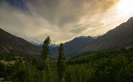
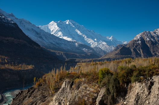
Hunza Valley in the Gilgit-Baltistan region of northern Pakistan is the highest permanently settled valley system in the world — a 30-km valley at 2,438 m surrounded by peaks above 7,000 m. The Karakoram Highway (KKH, completed 1979, the highest paved international road in the world) runs through Hunza connecting Islamabad to the Chinese border at Khunjerab Pass (4,693 m). Within 50 km of the Hunza Valley floor: Rakaposhi (7,788 m), Ultar Sar (7,388 m), Bojahagur Duanasir II (7,329 m), and the view from Altit Fort toward Rakaposhi is considered one of the great mountain panoramas of the world. The Hunza people are predominantly Ismaili Muslim (followers of the Aga Khan), and the Aga Khan Development Network has invested heavily in the region's education, healthcare, and heritage preservation since the 1980s.
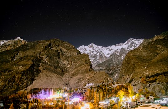
Karimabad — the main town of Hunza — sits at 2,500 m, 1 km above the Hunza River. The Baltit Fort (built in the 13th–15th century, restored by the Aga Khan Trust for Culture 1990–1996, opens 9 a.m., PKR 500) is the former residence of the Mir (ruler) of Hunza and the most significant historical building in northern Pakistan. The fort is built on a cliff face above Karimabad with the view of Rakaposhi (7,788 m) directly to the southeast — one of the most specific architectural-to-mountain views anywhere. The Altit Fort (3 km below Karimabad, the older of the two forts, 1,000 years old, restored 2007, opens 9 a.m., PKR 400) has the longest continuously inhabited site documentation in the region and an intact 11th-century interior chamber.
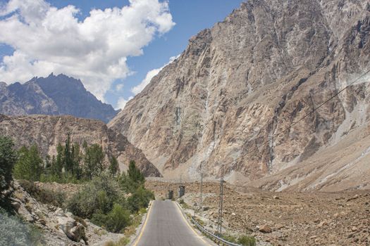
The Karakoram Highway passes through the most geologically violent landscape accessible by paved road: Attabad Lake (created in 2010 when a landslide blocked the Hunza River, the village of Attabad is submerged 90 m below the lake surface), the Khunjerab Pass (4,693 m, the world's highest paved border crossing, 130 km north of Karimabad), and the confluence of three great mountain ranges (the Karakoram, the Hindu Kush, and the Himalayas) in a single drive north from Hunza. The best mountain views in Hunza are from Eagle's Nest viewpoint (3,100 m, 7 km above Karimabad, 2-hour drive on a dirt road) at sunrise — the predawn light illuminates Rakaposhi and Ultar Sar while the valley below is still in shadow.
最佳出游月份 — Hunza Valley?
我们推荐的月份是 May–October. 以下是逐月规划参考。
精选体验 — Hunza Valley
由我们的本地合作伙伴精心挑选的旅行体验。每次定制旅游都包含其中部分——或更好的选择。
行程样本
两个出发方案——您的实际行程将完全定制。我们从此出发。
7天经典线路
- 1第 1: Islamabad to Gilgit — Flight & DriveFly from Islamabad Benazir Bhutto Airport (ISB) to Gilgit Airport (GIL, PIA or private charter, 1 hour, PKR 8,000–12,000). Note: Gilgit flights are among the most weather-dependent commercial flights in the world — the approach through the Karakoram requires visual flight rules and cancels in cloud or precipitation. Build a weather buffer day into your itinerary. Alternatively: the KKH road from Islamabad to Gilgit (550 km, 12–14 hours drive). From Gilgit: 2-hour drive north to Karimabad on the KKH. The drive passes Rakaposhi viewpoint (a roadside rest stop with a photogenic face of Rakaposhi at highway level). Arrive Karimabad, check in to a local guesthouse (Serena Hotel or local family guesthouses from USD 30–150/night).
- 2第 2: Eagle's Nest SunriseDepart Karimabad by 4WD at 4 a.m. for Eagle's Nest (3,100 m, 7 km above Karimabad on a steep dirt track, 45-minute drive in 4WD, impassable by standard car). Arrive before sunrise (typically 6–7 a.m., seasonal variation). The Eagle's Nest ridge provides a 180-degree panorama of the Karakoram: Rakaposhi (7,788 m) directly south, Ultar Sar (7,388 m) to the southwest, Bojahagur (7,329 m) to the west, and the Hunza Valley 700 m below in the shadow. The predawn light turns the snow peaks from pink to gold while the valley below is still dark — the most specific Hunza photograph. Return to Karimabad for breakfast.
- 3第 3: Baltit Fort & KarimabadBaltit Fort opens at 9 a.m. (PKR 500, last entry 5 p.m.). The fort (13th–15th century, Tibetan architectural influence visible in the corner towers) was the residence of the Mirs of Hunza until 1945. The Aga Khan Trust for Culture restoration (1990–1996) preserved the original structure; the third-floor reception room has the original carved cedarwood ceiling and window shutters. The basement dungeon and the roof terrace (the best Rakaposhi view from the fort) complete the 1-hour guided tour. Karimabad village walk: the bazaar (dried apricots — Hunza is the world's largest per-capita apricot producer, the dried variety is the staple winter food), local walnut and mulberry products, and the Aga Khan memorial garden.
- 4第 4: Altit Fort & Ancient VillageDrive 3 km downhill to Altit (the original Hunza settlement, below the current Karimabad). Altit Fort (opens 9 a.m., PKR 400): the 11th-century fort base with an interior chamber from this period intact — the oldest surviving building in Gilgit-Baltistan. The Altit village walk (the Aga Khan Trust has restored 30 traditional houses in the old village) shows the vernacular architecture of the Hunza people — flat-roofed stone houses with carved wooden verandahs, the communal water channel system (falak), and the terraced orchards below the fort. View from the Altit Fort roof: the Hunza River gorge 500 m below, the terraces on the opposite valley wall, and the Rakaposhi massif framed by the fort's carved window.
- 5第 5: Attabad Lake & GulmitDrive 30 km north from Karimabad to Attabad Lake. The lake was created in January 2010 when a massive landslide blocked the Hunza River — the lake is 21 km long, 100 m deep, and turquoise-blue from glacial melt. The original village of Attabad is 90 m below the surface. Boat trip across the lake (local wooden boats, PKR 500 per person, 30 minutes) — the turquoise water against the dry ochre cliffs is visually extraordinary. The KKH resumes on the far shore (tunneled through the landslide material by Pakistan Army engineers in 2015). Continue to Gulmit village (the largest Wakhi-speaking village in Pakistan, 2,800 m) and the Gulmit Museum (local Wakhi cultural artefacts, open by request). Return to Karimabad.
- 6第 6: Khunjerab Pass — 4,693 mDrive 130 km north from Karimabad to Khunjerab Pass (allow 3.5 hours each way, total 7 hours road). The KKH ascends from 2,500 m to 4,693 m through increasingly barren alpine landscape — the treeline ends at 3,200 m, the vegetation at 3,800 m, and above 4,000 m only the Khunjerab National Park wildlife remains (Marco Polo sheep, ibex, snow leopard tracks). Khunjerab Pass itself: the Pakistan-China border at the highest surveyed point of a paved road in the world. The air at 4,693 m has 40% less oxygen than at sea level — altitude sickness is possible if you ascend from Karimabad (2,500 m) in one day without acclimatisation. Spend 30–45 minutes at the pass and descend immediately.
- 7第 7: Cherry Blossom Walk (April–May) & DepartureApril–May only: the Hunza Valley cherry blossom season transforms the terraced orchards — 70,000 cherry trees bloom over 10–14 days, the timing varies by year and elevation (lower orchards bloom 1 week before upper). The Duikar and Haiderabad village orchards (accessible by 4WD above Karimabad) are the most photogenic. Return drive to Gilgit for the flight back to Islamabad (or the KKH drive). The Gilgit bazaar for the best dried apricot selection (the Hunza apricot oil is the finest in the world — cold-pressed from the kernels, used in cosmetics and cooking).
14天深度游
- 1第 1: Islamabad to HunzaISB–GIL flight (weather-dependent, 1 hour, PIA) or KKH 12-hour drive, Rakaposhi roadside viewpoint, Karimabad guesthouse.
- 2第 2: Eagle's Nest Sunrise4 a.m. 4WD departure, 3,100 m ridge, Rakaposhi gold at dawn, Hunza Valley 700 m below in shadow, 180-degree Karakoram panorama.
- 3第 3: Baltit Fort9 a.m. opening (PKR 500), Aga Khan Trust restoration 1990–96, Tibetan-influenced architecture, carved cedar ceiling, Rakaposhi roof view.
- 4第 4: Altit Fort & Village Walk11th-century base chamber, Aga Khan restored 30 traditional houses, falak water channel system, Hunza River gorge 500 m below.
- 5第 5: Attabad Lake Boat2010 landslide-created lake, submerged village 90 m below, turquoise glacial water, PKR 500 boat crossing, KKH tunnel 2015.
- 6第 6: Khunjerab Pass 4,693 m130 km north (3.5 hours), world's highest paved border, Marco Polo sheep, snow leopard territory, 40% less oxygen — acclimatise before ascending.
- 7第 7: Gulmit & Wakhi CultureWakhi-speaking community, Gulmit Museum local artefacts, Wakhi embroidery and textile tradition, glacier viewpoint above the village.
- 8第 8: Rakaposhi Base Camp TrekDay trek to Rakaposhi Base Camp (12 km return, 1,600 m elevation gain, 7–8 hours): the most accessible 7,000+ m peak base camp in Pakistan, guide recommended, excellent acclimatisation at 4,000 m.
- 9第 9: Naltar Valley50 km south of Gilgit: 3 coloured lakes at 3,500 m (the Naltar Lakes change from blue to green to turquoise with the season), the highest ski resort in Pakistan (Naltar Ski Resort, 3,800 m, operates December–March), natural beauty without tourist infrastructure.
- 10第 10: Cherry Blossom Orchard Walk (April–May)Duikar village cherry orchards, 70,000 trees in 10-day bloom, altitude variation determines timing, traditional Hunza farmhouse lunch.
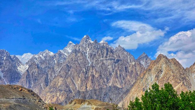
- 11第 11: Passu Cones & Cathedral Peaks50 km north of Karimabad: the Passu Cones (the sharpest rock peaks in Pakistan, 7 rock needles rising from the valley floor, the most photographed Karakoram formation after K2) and the Batura Glacier (one of the longest glaciers in the world outside the polar regions).
- 12第 12: Shimshal Valley Drive80 km east of Passu: the remote Shimshal Valley (the last valley added to the KKH network, connected by road only in 2003) — the home of the Shimshal women who carry loads at 5,000 m for the shepherding culture.
- 13第 13: Karimabad Sunset & Apricot Harvest (July–Aug)July–August apricot harvest: the terraced orchards above Karimabad, the apricot-drying racks on rooftops, the family harvest activity, and the fresh apricot (available from July, the best in the world by most accounts).
- 14第 14: Final Eagle's Nest & DepartureSecond Eagle's Nest dawn (for the clear-day view that weather may have prevented on Day 2), return to Gilgit airport, ISB connection.
实用信息
常见问题
How do I get to Hunza Valley?+
The most practical route is flying from Islamabad to Gilgit (PIA, 1 hour, PKR 8,000–12,000 one way) followed by a 2-hour drive on the KKH to Karimabad. The Gilgit flight is among the most weather-dependent commercial routes in the world — the approach requires visual conditions and cancels frequently in cloud, fog, or precipitation. Build 1–2 extra days into your schedule for flight delays. The alternative is the KKH road from Islamabad to Gilgit (550 km, 12–14 hours by private vehicle or 15–18 hours by public bus) — the road is paved and passes through spectacular scenery but is physically demanding. From Gilgit to Karimabad: 2 hours by private vehicle on the KKH (no direct public transport, hire a vehicle in Gilgit, PKR 3,000–5,000).
Is Hunza Valley safe for tourists?+
Gilgit-Baltistan has been consistently safe for tourists since the region was opened to international visitors in the 1970s. The area experienced sporadic security incidents in 2012–2013 (the Nanga Parbat mountaineer attack) and 2021 (isolated road incidents) that resulted in temporary travel advisories from some governments. As of 2024, major Western governments rate Gilgit-Baltistan as generally safe with standard precautions. The Hunza Valley specifically is culturally conservative but welcoming to tourists — the Ismaili Muslim tradition in Hunza is notably moderate and the community has benefited economically from tourism for 50+ years. Female travellers: Hunza is more comfortable for solo female travellers than most of Pakistan.
When should I visit Hunza Valley?+
April–May is the blossom season — cherry and apricot trees bloom from mid-April to mid-May (lower orchards first, upper orchards 1 week later). This is the most visually spectacular time but also the busiest. June is the transition to summer with clear skies and warm days, less crowded. July–August is peak summer — the apricot harvest, warm weather, and clearest mountain visibility (the monsoon that affects the rest of Pakistan rarely reaches Hunza). September–October is the second optimal window: the poplar trees turn gold, the harvest is complete, and the crowds thin. November–March: the pass above 3,000 m closes with snow; Karimabad at 2,500 m is cold but accessible and the mountain views are best in winter's clear air.
What is the Karakoram Highway?+
The Karakoram Highway (KKH) is a 1,300-km road connecting Islamabad (Pakistan) to Kashgar (China) via the Khunjerab Pass (4,693 m). It follows the ancient Silk Road trade route through the Indus, Hunza, and Gilgit river valleys and crosses some of the most geologically active terrain on Earth. Construction began in 1959 and was completed in 1979 by joint Pakistani and Chinese labour (approximately 810 workers died during construction — one for every 1.6 km). The KKH was described by the Guinness Book of Records as the 'eighth wonder of the world' for its engineering. It is prone to closure from landslides (hundreds per year — the 2010 Attabad landslide blocked the road for 5 years), and travellers should check the current road status before departing.
What are the apricots of Hunza?+
Hunza is reputedly the world's largest per-capita apricot producer — the terraced orchards cover every cultivable slope in the valley, and the apricot forms the core of the traditional Hunza diet (eaten fresh in July–August, dried on rooftop racks in August, and consumed as the primary winter food for 8 months). The Hunza apricot varieties (particularly Muttee and Shah Mardan) are noted for their exceptional flavour — more complex and less sweet than commercially farmed varieties. The kernel oil (cold-pressed from the apricot seed) is used in cooking, cosmetics, and traditional medicine. Dried Hunza apricots are available at the Karimabad bazaar and at the Gilgit bazaar; the fresh apricot season is July 1–August 15.
大家还问
- Is Hunza Valley worth visiting?
- How do I get to Hunza Valley from Islamabad?
- What is the best time to see cherry blossom in Hunza?
- Is Hunza Valley safe for tourists?
- What is the Karakoram Highway?
- What is the altitude of Hunza Valley?
- Where is Khunjerab Pass?
- What is Baltit Fort?
准备好规划您的 Hunza Valley之旅了吗?
与我们的AI礼宾助手交流——只需两分钟描述您的梦想旅行。