Individuelle Reisen nach Atacama Desert
The driest desert on Earth — geysers, salt flats, and stars.
Was ist eine Individualreise nach Atacama Desert?
The Atacama's essential sequence: El Tatio Geysers (4 a.m. departure, 6 a.m. eruption at −10°C), Valle de la Luna sunset (5 p.m., salt formations glow orange), stargazing with SPACE Atacama (9 p.m., 350 clear nights/year). Fly into Calama (CJC), 1 hour from San Pedro de Atacama. Best season: March–November (clearest skies). December–February is the 'Bolivian winter' — afternoon thunderstorms on the altiplano. Altitude warning: 2,400 m in San Pedro, 4,321 m at El Tatio — acclimatise in Calama first.
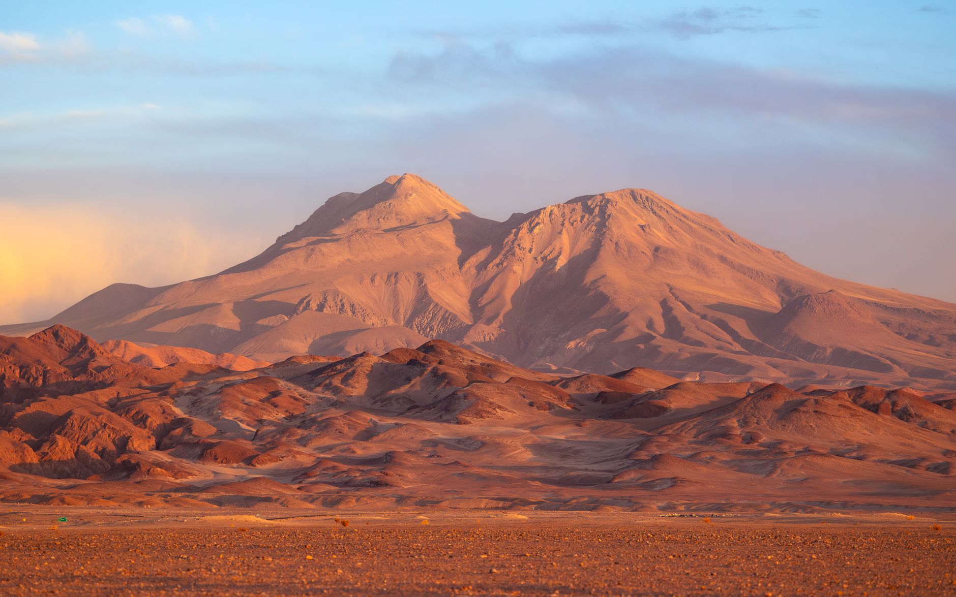
The Atacama Desert is the driest non-polar desert on Earth — the Atacama core (the Central Valley between the Coastal Range and the Andes, from Arica in northern Chile south to Copiapó) receives less than 1 mm of rainfall per year in places. Some weather stations in the Atacama have never recorded measurable rainfall. The desert sits on a rain shadow double-blocked by the Andes to the east (blocking Amazon moisture) and the Coastal Range to the west (blocking Pacific moisture), creating a hyperarid zone 1,000 km long. The consequence: in the Atacama core, geological formations visible today have been exposed for millions of years without erosion — the Valley of the Moon (Valle de la Luna) salt formations near San Pedro de Atacama were last covered by water 3 million years ago.
San Pedro de Atacama (2,407 m altitude, the main tourist hub in the Atacama) is surrounded by salt flats, volcanoes, geysers, and the world's best stargazing: at 2,400 m with zero moisture and 350+ clear nights per year, the Atacama has the lowest atmospheric light absorption of any inhabited area on Earth. The Atacama Large Millimeter Array (ALMA, 5,058 m, the world's largest radio telescope array with 66 antennas), the Very Large Telescope (Cerro Paranal, 2,635 m, the world's most productive ground-based telescope), and the future Extremely Large Telescope (currently under construction at Cerro Armazones, 3,046 m) are all in the Atacama because of this atmospheric transparency. The Atacama Night tour operators (SPACE at atacamaspace.com, USD 40, 9 p.m. to midnight with 40-cm computerized telescopes) provide the best guided stargazing experience for non-astronomers.
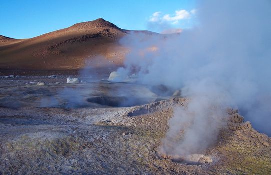
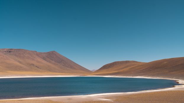
The El Tatio Geyser Field (4,321 m altitude, 80 km north of San Pedro, the highest-elevation geyser field in the world with 80 active geysers) erupts most vigorously between 6 and 7 a.m. — the cold high-altitude air (−10°C at dawn) causes the steam from the 85°C vents to condense immediately into visible columns. Tour departure at 4 a.m. from San Pedro arrives at 6 a.m. for peak geyser activity. The Laguna Cejar (high-buoyancy salt lake, Dead Sea-equivalent salinity, 2.5 km from San Pedro, float in 12°C water — bring a water bottle for rinsing), the Tebinquinche Lagoon sunset (the flamingos in the foreground, the salt crust of the Atacama Salar reflecting the sunset sky), and the Licancabur Volcano (5,916 m, the perfect cone visible from San Pedro at sunrise, the highest lake in the world at its crater — 5,916 m — a small pond that astronomers use as a Mars-environment analogue).
Was ist die beste Reisezeit für Atacama Desert?
Unsere empfohlenen Monate sind April–October (dry). Hier ein monatlicher Überblick mit Planungshinweisen.
Highlights in Atacama Desert
Handverlesene Erlebnisse unserer lokalen Veranstalter. Jede Individualreise beinhaltet eine Auswahl davon — oder etwas noch Besseres.
Musterreiserouten
Zwei Ausgangspunkte — Ihre echte Reiseroute ist individuell. Wir bauen darauf auf.
7 Tage Klassiker
- 1Tag 1: Arrival Calama & Transfer to San PedroFly into Calama Airport (CJC, LATAM or Sky from Santiago, 2 hours). Acclimatise in Calama (2,260 m) for the afternoon before driving to San Pedro de Atacama (100 km southeast, 1.5 hours via CH-23, 2,407 m). Altitude note: El Tatio at 4,321 m is nearly 2,000 m higher than San Pedro — even acclimatised visitors can experience headache and fatigue at geyser field altitude. On the road between Calama and San Pedro: the Atacama salt flats begin as the valley narrows, the Licancabur Volcano (5,916 m perfect cone) appears on the horizon, and the first flamingo sightings are possible in the Salar de Atacama boundary lagoons. San Pedro de Atacama town: the adobe buildings, the Calle Caracoles (the tourist street with tour operators, restaurants, and gear shops), and the Iglesia de San Pedro (the 1641 mud-and-cactus-wood church, the oldest surviving church in Chile).
- 2Tag 2: El Tatio Geysers at DawnDepart San Pedro at 4 a.m. (tour operator shuttles, USD 35–45 including breakfast, or private 4WD — the road is unpaved for the final 30 km and 4WD is recommended in wet season). Arrive El Tatio at 6 a.m. for peak geyser activity: 80 active vents at 4,321 m erupting steam (at −10°C ambient temperature the steam condenses to dramatic white columns — the display peaks in the first 30–45 minutes of sunrise when the temperature differential is greatest). Do not step close to the vents — the ground crust is thin and the 85°C water below has killed visitors who broke through. A natural hot spring pool (35°C, concrete-rimmed, immediately adjacent to the geyser field) is available for bathing. Return to San Pedro by 11 a.m., stopping at Machuca (the small highland village at 4,000 m, llama and alpaca farmers, the adobe chapel, roasted llama skewers from the roadside vendors).
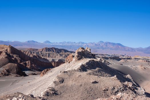
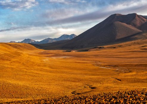
- 3Tag 3: Valle de la Luna & SunsetValle de la Luna (Valley of the Moon, 15 km west of San Pedro, CLP 5,000/USD 6 entry, open 8 a.m.–11 p.m.): the CONAF-protected salt and rock formations in the Cordillera de la Sal. The Gran Duna (the largest sand dune in the valley, 30-minute climb): the view from the top at 5 p.m. as the late afternoon light turns the salt formations orange, then red, then purple — the Valley of the Moon is most spectacular in the 30 minutes before and after sunset. The salt caves (Cueva de Sal): formed by the dissolution and recrystallization of salt, the chambers have salt crystal walls. The amphitheatre viewpoint (opposite the Duna Mair): the rounded salt hills around the depression in the late afternoon light. The valley was named by astronauts who found it the closest accessible terrestrial analogue to the lunar surface — NASA has used it for Mars rover testing.
- 4Tag 4: Altiplano Lagoons & FlamingosDay tour to the Altiplano Lagoons (tour operator, USD 50–70, departs 8 a.m., 4WD only): Laguna Miscanti (4,200 m, deep blue crater lake, the volcano Miscanti as backdrop — the deepest blue you will see at this altitude), Laguna Miñiques (adjacent, similar altitude, turquoise where shallow, dark blue where deep), and Laguna Chaxa (within the Salar de Atacama, flamingo breeding habitat). Three flamingo species in the Atacama: the Andean flamingo (Phoenicoparrus andinus, the rarest, yellow legs), the Chilean flamingo (Phoenicopterus chilensis, pink legs), and James's flamingo (Phoenicoparrus jamesi, brick-red beak). Altitude warning: the Altiplano lagoons are at 4,000–4,500 m — even at rest you may feel breathless. Descend to San Pedro immediately if you feel confused or unwell (signs of altitude sickness).
- 5Tag 5: Stargazing Night TourStargazing with SPACE Atacama (atacamaspace.com, USD 40–50, departs 9 p.m., 2.5 hours, book ahead — groups are capped at 20 to prevent light pollution from other participants): the Atacama's 350+ clear nights per year, zero humidity, and 2,400 m altitude mean that the Milky Way is visible with the naked eye in a band that extends from horizon to horizon. The southern hemisphere sky from the Atacama includes: Alpha Centauri (the nearest star system to the Sun, 4.37 light-years — visible as a bright point near the Southern Cross), Omega Centauri (the largest globular cluster in the Milky Way, containing 10 million stars — visible with the naked eye as a fuzzy star), and the Large and Small Magellanic Clouds (dwarf galaxies orbiting the Milky Way, visible only from the Southern Hemisphere). The 40-cm computerized telescope brings Saturn's rings and Jupiter's moons into view.
- 6Tag 6: Laguna Cejar & Tebinquinche SunsetLaguna Cejar (2.5 km south of San Pedro, private property, USD 15, opens 10 a.m.–7 p.m.): a high-salinity lake where the salt concentration is high enough for effortless floating — lie on your back in 12°C water and the buoyancy holds you without effort. The lake surface is white-rimmed with salt crystal formations. The adjacent Ojos de Salar: the circular 'eyes' of the Salar de Atacama where underground brine surfaces — perfectly circular pools in the salt flat. Tebinquinche Lagoon (same day tour, 15 km further into the salar, USD 15 additional): arrive 45 minutes before sunset as the flamingos feed in the shallow water — the salt crust of the Atacama Salar reflects the sky in terracotta and pink, the flamingos silhouetted against the reflected colour, the Andes 50 km east turned gold.
- 7Tag 7: Petroglyph Sites & DepartureYerbas Buenas Petroglyph Site (30 km south of San Pedro, free, self-guided): the 800–1,000-year-old rock engravings (petroglyphs) of the Atacameño culture — llamas, human figures, and solar symbols carved into the dark volcanic rock of the valley wall. The petroglyphs are in a sheltered canyon where the rock surface is protected from wind erosion — the detail is extraordinary for incised images of this age. Pukará de Quitor (3 km from San Pedro, CLP 3,000, open 9 a.m.–6 p.m.): the pre-Inca defensive fortress on the cliff above the San Pedro River, built between 900–1450 CE by the Atacameño people — the partial reconstruction allows the original defensive wall design to be understood. Return to Calama for CJC departure (the afternoon LATAM to Santiago connects to international flights).
14 Tage Tieftauchen
- 1Tag 1: Arrival Calama & AcclimatisationCJC from Santiago 2 hours, acclimatise in Calama 2,260 m afternoon, drive CH-23 to San Pedro 1.5 hours, Licancabur Volcano 5,916 m on horizon, Iglesia de San Pedro 1641 (oldest church in Chile).
- 2Tag 2: El Tatio Geysers4 a.m. departure USD 35–45, 6 a.m. arrival 4,321 m (world's highest geyser field), −10°C + 85°C vents = steam columns, 80 active geysers, hot spring pool 35°C, Machuca village llama skewers.
- 3Tag 3: Valle de la Luna SunsetUSD 6 entry, Gran Duna 30-min climb, salt formations orange-red in 30-min pre-sunset window, salt caves crystal walls, NASA Mars rover test site, Cordillera de la Sal formations.
- 4Tag 4: Altiplano LagoonsUSD 50–70 4WD tour, Laguna Miscanti 4,200 m crater lake, Laguna Miñiques turquoise shallows, Laguna Chaxa flamingo breeding (Andean, Chilean, James's — three species same site).
- 5Tag 5: StargazingSPACE Atacama USD 40–50, 9 p.m. 2.5 hours, 350+ clear nights, Milky Way horizon-to-horizon, Alpha Centauri 4.37 light-years, Omega Centauri 10 million stars naked eye, Magellanic Clouds Southern Hemisphere only.
- 6Tag 6: Laguna Cejar FloatingUSD 15, Dead Sea-equivalent salinity, effortless floating 12°C, white salt crystal rim, Ojos de Salar circular brine springs, Tebinquinche flamingo sunset USD 15.
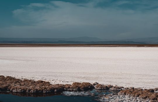
- 7Tag 7: Salar de Atacama CoreSalar de Atacama (160,000 hectares, world's largest lithium deposit — 30% of global reserves in the brine beneath), Peine village (Atacameño community, salt mining tradition), salt flower formations at the salar centre.
- 8Tag 8: Yerbas Buenas PetroglyphsFree, 800–1,000-year-old Atacameño rock engravings, llamas and solar symbols in sheltered volcanic canyon, Pukará de Quitor defensive fortress CLP 3,000 (900–1450 CE Atacameño culture).
- 9Tag 9: Quebrada de Concón & CatarpeQuebrada de Concón (free day hike, 8 km round-trip, the rock canyon with salt crystal formations on the walls), Catarpe ruins (the Inca administrative centre above the San Pedro Valley, 1430–1536 CE, the southernmost Inca provincial capital in the altiplano system).
- 10Tag 10: Desert Night HikeNight hike to the Cordillera de la Sal (operator-guided, USD 30, 3 hours, sunset to full dark): the stars begin while you're still walking — the transition from alpenglow on the salt mountains to full Milky Way visibility takes 45 minutes, walked in real time.
- 11Tag 11: San Pedro to Bolivia — Uyuni Salt FlatCross into Bolivia via Hito Cajón border (4WD tour, 3-day Bolivia circuit USD 150–200 with San Pedro operators): Laguna Verde, Laguna Colorada (the red lake from Artemia algae), the Uyuni Salt Flat (the largest mirror surface on Earth in rainy season, November–March, the dry hexagonal crust pattern April–October).
- 12Tag 12: Uyuni Salt FlatSalt Flat 10,582 km², 3,650 m altitude, 10-metre deep salt crust, perspective photography horizon in every direction, Incahuasi Island (cactus island at the centre, 30-km drive on the salt), Colchani salt extraction community.
- 13Tag 13: Return San Pedro & Farewell SunsetReturn from Bolivia via border, final Valle de la Luna sunset (the second visit always produces different light — the season, the time of year, and the dust in the air change the colour), San Pedro Calle Caracoles final dinner.
- 14Tag 14: DepartureSan Pedro–Calama transfer (1.5 hours), CJC LATAM to Santiago (2 hours), Santiago international connections, altitude note: Calama to sea level can produce reversed altitude symptoms (some people feel dizzy descending rapidly from 2,400 m).
Praktische Informationen
Häufig gestellte Fragen
Why is the Atacama the driest desert on Earth?+
The Atacama Desert experiences extreme aridity due to a combination of three factors: the rain shadow of the Andes Mountains to the east (blocking warm, moisture-laden air from the Amazon basin), the rain shadow of the Chilean Coastal Range to the west (blocking Pacific air), and the cold Humboldt Current (the cold South Pacific ocean current running north along Chile's coast that creates a stable atmospheric inversion layer, preventing moisture from rising and forming rain-producing clouds). The result: the central Atacama averages less than 1 mm of rainfall per year. The Atacama core between the Coastal Range and the Andes has some of the longest periods without measurable rainfall ever recorded — the Yungay station in Chile went 173 months (over 14 years) without rain. This aridity has preserved geological formations for millions of years.
What are the El Tatio Geysers?+
El Tatio (from the Quechua word for 'oven' or 'grandfather who cries') is the world's largest geyser field in the Southern Hemisphere and the highest-elevation geyser field in the world (4,321 m). The field has approximately 80 active geothermal vents that erupt steam and superheated water from underground volcanic heat sources. The spectacle is temperature-dependent: the vents release water at approximately 85°C year-round, but the visible steam columns (the cloud that makes the geysers dramatic to photograph) form only when the ambient air temperature is cold enough to cause the steam to condense — this is why the 6–7 a.m. window, when air temperatures at this altitude are −10°C, produces the most dramatic displays. By 9 a.m., as the air warms, the columns become invisible. The safety warning: the ground crust around the vents is thin calcium carbite and can collapse — several tourists have been severely burned or killed by falling into active vents.
Why is the Atacama the best place for stargazing?+
The Atacama Desert offers the best conditions for astronomical observation of any inhabited area on Earth due to four factors: atmospheric transparency (zero humidity means no water vapour absorbing infrared and ultraviolet light), altitude (most observatories are at 2,400–5,000 m, above 40–60% of the atmosphere's mass), lack of light pollution (the Atacama core has no significant urban areas), and 320–350 clear nights per year (the subtropical high-pressure system creates near-permanent clear skies). The result: the world's four largest telescope projects are in the Atacama — the VLT (Very Large Telescope), ALMA (Atacama Large Millimeter Array), the future ELT (Extremely Large Telescope, under construction), and the Simonyi Survey Telescope (Vera Rubin Observatory). For visitors, the Atacama Night tour operators (SPACE Atacama, Astro Atacama) provide access to 40-cm telescopes with computer guidance for around USD 40.
What is the altitude risk in the Atacama?+
San Pedro de Atacama is at 2,407 m — an altitude where most visitors experience minimal symptoms with careful acclimatisation (arriving from sea level, spending the first night at moderate altitude in Calama at 2,260 m before driving to San Pedro). El Tatio Geyser Field is at 4,321 m — a significant altitude jump for which most visitors are inadequately acclimatised. Symptoms at El Tatio can include headache, nausea, dizziness, and breathlessness even in healthy individuals. Altitude sickness (acute mountain sickness, AMS) symptoms: headache + at least one of nausea, fatigue, dizziness, or poor sleep. If symptoms include confusion, loss of coordination, or a wet cough, descend immediately. The standard precautions: hydrate well, avoid alcohol the first 48 hours, ascend slowly, and consider prophylactic acetazolamide (125 mg twice daily, starting 24 hours before ascent) if you have had AMS before — discuss with a doctor.
What is the best time to visit the Atacama?+
March through November is the optimal window. December through February is the 'Bolivian winter' (altiplano winter in Bolivia and Argentina, but ironically a wet season) — afternoon thunderstorms affect the high-altitude areas (El Tatio, the Altiplano lagoons above 4,000 m) from December–February, with the possibility of roads flooding or closing. However, the altiplano wildflowers (the phenomenon called 'desierto florido' or blooming desert) occur in certain years when exceptional rainfall falls — most memorably in 2015, when the Atacama bloomed in carpets of pink and purple after unusual rain events. The 'desierto florido' is unpredictable and occurs perhaps once per decade in spectacular form. Stargazing quality is consistent year-round; the September–November period has somewhat longer nights than the summer months.
Andere fragen auch
- Why is the Atacama the driest desert on Earth?
- What are the El Tatio Geysers?
- Why is the Atacama good for stargazing?
- What is the altitude risk at El Tatio?
- What is the best time to visit the Atacama?
- Can you float in the Atacama Salt Flat?
- What flamingos live in the Atacama?
- What is the desierto florido in the Atacama?
Bereit, Ihre Atacama Desert-Reise zu planen?
Chatten Sie mit unserem KI-Concierge — zwei Minuten für Ihre Traumreise.