جولات مخصصة إلى Kilimanjaro
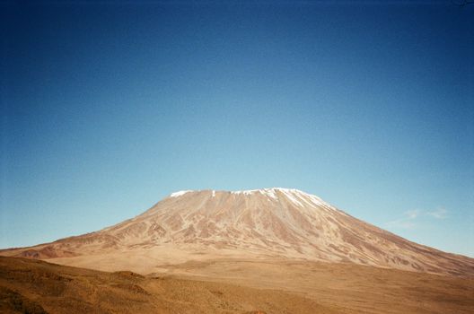
Africa's rooftop — 5,895m, a glaciated volcano near the equator.
ما هي الجولة المخصصة إلى Kilimanjaro?
Kilimanjaro is best approached via the Lemosho Route (8 days, best acclimatisation profile, most scenic) or the Machame Route (7 days, most popular, 70–80% summit rate). Book through a TANAPA-licensed operator at least 3 months ahead. Budget: USD 2,000–3,500 all-inclusive (guide, porters, park fees, accommodation). Best season: January–March and June–October.
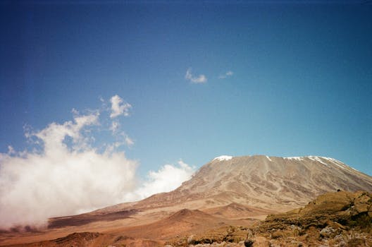
Mount Kilimanjaro (5,895 m, Tanzania) is the highest peak in Africa and the world's highest free-standing mountain — a dormant stratovolcano that rises 5,200 metres above the Tanzanian plain in a single unbroken massif, creating its own weather system and five distinct vegetation zones from savanna to Arctic ice field. Kilimanjaro is the most climbed high-altitude peak in the world (50,000–60,000 summit attempts per year, approximately 65% summit success rate) because no technical climbing skill is required — the Uhuru Peak summit (5,895 m) is accessible via hiking on all six official routes. The primary limiting factor is altitude: at 5,895 m, the air contains 47% of the oxygen available at sea level.
The Lemosho Route (7–8 days, the longest and most scenic approach, starting from the Lemosho Glades in the west) is considered the optimal route for acclimatisation (the gradual altitude gain and the time at intermediate elevations reduces acute mountain sickness risk) and for scenery (the western approach passes through the Shira Plateau and the Southern Ice Fields views). The Marangu Route (5–6 days, the only route with hut accommodation, nicknamed the 'Coca-Cola Route' for its relative comfort) has the lowest summit success rate (45–50%) because the ascent profile is too fast for proper acclimatisation. The Machame Route (6–7 days, the most popular) has a good summit success rate (70–80%) and traverses the most visually varied terrain. All routes require a licensed TANAPA guide (mandatory), porter hire (strongly recommended, KPAP-registered porters who are treated ethically), and the national park fees (USD 70–80 per day).
The Stella Point (5,756 m) to Uhuru Peak (5,895 m) final section is a 139-metre altitude gain along the crater rim — the section that breaks many trekkers' resolve at 3–5 a.m. after a midnight summit push in -20°C. The crater rim provides the first view of the Southern Ice Fields: the remnant glaciers of Kilimanjaro that have retreated 82% since 1912 and are projected to disappear entirely by 2040. The Furtwängler Glacier, the largest remaining ice on the crater floor, is visible from Uhuru Peak as a shrinking white mass — a more immediate climate change indicator than abstract statistics.
ما هو أفضل وقت لزيارة Kilimanjaro?
الأشهر الموصى بها لدينا هي January–March, June–October. إليك نظرة شهرية مع ملاحظات التخطيط.
أبرز التجارب في Kilimanjaro
لحظات منتقاة بعناية من مشغّلينا المحليين. كل جولة تتضمن مجموعة مختارة منها — أو شيئاً أفضل إن وجدناه.
مسارات نموذجية
نقطتا انطلاق — مسارك الحقيقي مخصص تماماً. نبني من هنا.
7 أيام كلاسيكية
- 1يوم 1: Arrival Kilimanjaro — Machame GateFly into Kilimanjaro International Airport (JRO, 45 km from Arusha — well-served from Amsterdam/Nairobi/Addis Ababa/Doha). Check into Moshi or Arusha for the pre-climb gear check and briefing with your licensed operator. The KPAP (Kilimanjaro Porters Assistance Project) certification on your operator confirms porters receive fair wages, appropriate equipment, and safe loads (max 20 kg per porter). Equipment review: layering system for -20°C summit, gaiters (mud on lower slopes), headlamp (midnight summit push), trekking poles (critical for descent). Machame Gate (1,830 m, 35 km from Moshi, 1.5-hour drive).
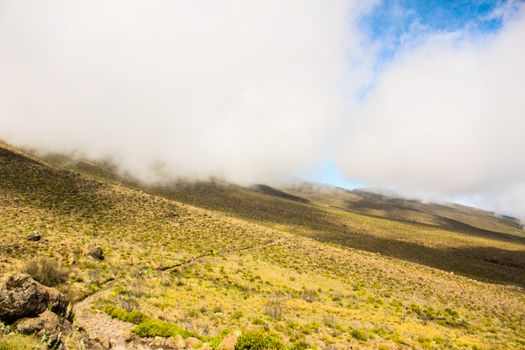
- 2يوم 2: Machame Gate to Machame Camp — RainforestMachame Gate (1,830 m) to Machame Camp (3,010 m): 11 km, 5–7 hours, 1,180 m elevation gain. The first day is through montane rainforest — the tree canopy closes overhead, colobus monkeys call from above, and the trail is slippery mud in wet season. The forest zone extends from 1,800 m to 2,800 m; above this it transitions to moorland. Arrive at Machame Camp for the first night at 3,010 m. The guide will conduct the 'pole pole' (slowly slowly) pace discipline — the most common mistake is walking too fast on Day 1 due to fitness and excitement. The rate of ascent, not physical fitness, determines summit success.
- 3يوم 3: Machame Camp to Shira Camp — MoorlandMachame Camp (3,010 m) to Shira Camp (3,840 m): 5 km, 4–6 hours, 830 m gain. The rainforest gives way to moorland — Helichrysum (everlasting flower), giant groundsel (Senecio kilimanjari, the giant succulent that grows only on Kilimanjaro above 3,500 m), and the first views of the Kibo summit cone with its ice cap. The porters typically arrive at camp before the trekkers to have tea and lunch waiting — the porter system is what makes Kilimanjaro accessible (porters carry all sleeping equipment, food, and cooking gear). First altitude testing: headache, appetite loss, and difficulty sleeping are early AMS signs — report to the guide immediately.
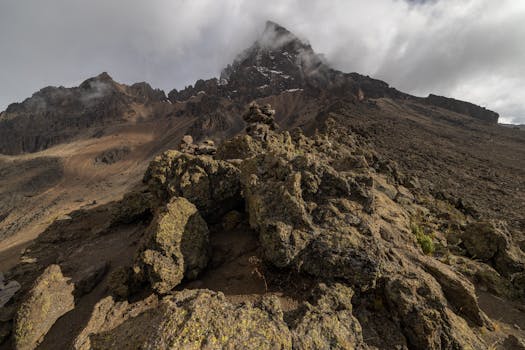
- 4يوم 4: Shira to Barranco — Lava Tower AcclimatisationShira Camp (3,840 m) to Barranco Camp (3,960 m): 10 km, 6–8 hours, with the Lava Tower acclimatisation detour. The route climbs to the Lava Tower (4,630 m) for the acclimatisation 'climb high, sleep low' protocol — ascending to 4,630 m then descending to 3,960 m. This single acclimatisation detour significantly increases summit success rates. The Lava Tower (a free-standing rock column of 300 m height) is at the base of the Western Breach — the most dangerous route to the summit (not recommended). The route passes the Southern Ice Field views for the first time at this altitude.
- 5يوم 5: Barranco Wall Scramble & Karanga CampBarranco Camp (3,960 m) to Karanga Camp (4,035 m): 5 km, 4–5 hours, including the Barranco Wall. The Barranco Wall is the most technical section of the Machame Route — a 300-metre scramble up a near-vertical rock face (assisted by the guide and the rock's natural handholds, not ropes, but genuinely scrambling with hands). The wall takes 1–2 hours; the view from the top is the most dramatic of the entire route — the summit cone directly above, the ice cliffs of the Southern Glaciers visible, and the Tanzania plain 4,000 m below. Karanga Camp is the last water source before the summit camp.
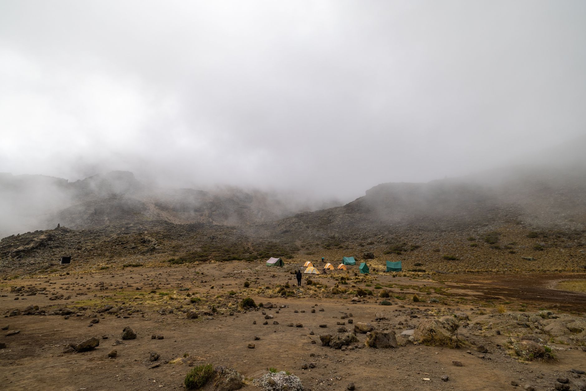
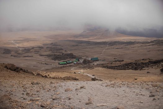
- 6يوم 6: Barafu Camp — Summit PreparationKaranga Camp to Barafu Camp (4,673 m): 4 km, 3–4 hours. Barafu ('ice' in Swahili) is the summit camp — a barren ridge at 4,673 m with views of the summit cone and the Rebmann and Ratzel glaciers. Arrive by noon for the maximum rest before the midnight summit push. Dinner at 5 p.m., attempt to sleep 6–11 p.m. (altitude makes sleep difficult — the guide will wake you at 11:30 p.m.). Summit push departs at midnight: full winter gear, headlamps, trekking poles. The summit push takes 6–8 hours (midnight to 6–8 a.m.). Altitude sickness risk is highest above 5,000 m — know the evacuation protocol.
- 7يوم 7: Summit Uhuru Peak & DescentThe midnight push: Barafu (4,673 m) to Stella Point (5,756 m) is 4–5 hours of steep scree in darkness. Stella Point is at the crater rim — the first of the two summit points. From Stella Point to Uhuru Peak (5,895 m): 1 hour along the crater rim. The summit: the Uhuru Peak sign, the Southern Ice Fields visible in the dawn light, and the 5,200-metre vertical fall to the Tanzanian plain below. Summit time at Uhuru: 15–20 minutes (cold, altitude, weather). Descent from Barafu to Mweka Camp (3,100 m): 5–6 hours down the Mweka Route — the knees take the primary impact. Arrive Mweka Gate (1,640 m) next morning. Certificate collection at gate.
14 يوماً تعمقاً
- 1يوم 1: Arrival Moshi & Gear CheckJRO airport, KPAP-certified operator briefing, equipment review (-20°C layering system, trekking poles, gaiters), Moshi hotel.
- 2يوم 2: Lemosho Route — Day 1: Lemosho GladesLemosho Glades start (2,100 m), Western Breach forest approach (9 km, 5 hours), first montane forest camp at 3,500 m.
- 3يوم 3: Lemosho Route — Day 2: Shira Ridge3,500 m to Shira Camp (3,840 m) via Shira Ridge: the most expansive views of the Shira Plateau, the largest volcanic caldera on Kilimanjaro.
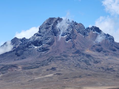
- 4يوم 4: Lemosho Route — Day 3: Moir CampNorthern circuit approach via Moir Hut (4,200 m): the least-trafficked section of Kilimanjaro, the northern route's scenery includes views of Mawenzi Peak (5,149 m, the second summit) and the Amboseli plain.
- 5يوم 5: Lemosho Route — Day 4: School HutNorthern approach continues to School Hut (4,750 m): acclimatisation walk to 5,000 m and return, the highest acclimatisation point before the summit camp.
- 6يوم 6: Lemosho Route — Day 5: Kibo Hut & BarafuConfluence with the Marangu Route at Kibo Hut (4,750 m) then deviation to Barafu (4,673 m) — the Lemosho route's summit camp on the Machame approach.
- 7يوم 7: Summit Push — Midnight Start11:30 p.m. departure, scree ascent Barafu to Stella Point (5,756 m) 4–5 hours, crater rim to Uhuru Peak (5,895 m) 1 hour, 15–20 minutes at summit, descent to Mweka Camp.
- 8يوم 8: Descent & Moshi RecoveryMweka Camp (3,100 m) to Mweka Gate (1,640 m), certificate collection, transfer to Moshi, summit recovery meal and sleep.
- 9يوم 9: Kilimanjaro National Park — Lower Forest WalkA non-summit day walk in the Kilimanjaro lower forest zone (Marangu Gate area, 1,860 m): colobus monkey observation, giant fig trees, and the river system that the mountain creates for the surrounding farmland.
- 10يوم 10: Arusha Day — Gateway CityArusha National Park day trip: the Ngurdoto Crater (the 'miniature Ngorongoro'), the alkaline Momela Lakes (flamingos), and the best close-up view of Kilimanjaro from the northern slope.
- 11يوم 11: Serengeti — Kilimanjaro Circuit Add-On2-hour drive from Arusha to the Serengeti Gate: the great wildebeest migration (1.5 million animals, specific timing varies — check the annual migration calendar before booking).
- 12يوم 12: Serengeti Game DriveBig Five in the southern Serengeti (Seronera), Grumeti River crocodiles, cheetah on the plains.
- 13يوم 13: Ngorongoro CraterUNESCO World Heritage: the world's largest intact volcanic caldera (260 km² floor), the most reliable black rhino viewing in Tanzania (15 remaining in the crater), the highest concentration of predators in Africa.
- 14يوم 14: Moshi Final Day & DepartureChagga coffee farm tour (the Chagga people of Kilimanjaro are the original Arabica coffee farmers of Tanzania — farm visit with traditional coffee processing), JRO airport departure.
معلومات عملية
الأسئلة الشائعة
Which Kilimanjaro route should I choose?+
For first-time climbers: the Lemosho Route (7–8 days) has the best acclimatisation profile and the most varied scenery, but it is more expensive (more park nights). The Machame Route (6–7 days) is the most popular with a good 70–80% summit success rate. The Marangu Route (5–6 days, the 'Coca-Cola Route' with hut accommodation) has the lowest summit success rate (45–50%) because it is the fastest and acclimatisation is inadequate. The Rongai Route (6–7 days) approaches from the north — drier conditions (rain shadow side) and a completely different forest zone. Choosing a longer route (7–8 days) rather than a shorter one is the single most important factor in summit success, regardless of route.
What is altitude sickness and how do I prevent it on Kilimanjaro?+
Altitude sickness (Acute Mountain Sickness, AMS) on Kilimanjaro is caused by ascending too fast for the body to produce additional red blood cells. Symptoms: headache, nausea, loss of appetite, dizziness, and insomnia. The Kilimanjaro risk is specific: the mountain ascends faster in altitude gain per km than most trekking destinations (from 1,800 m gate to 5,895 m summit in 5–8 days). Prevention: choose a longer route (more days above 3,000 m), walk 'pole pole' (the Swahili mantra — slow), hydrate consistently (3–4 litres/day), and don't over-exert on early days. Diamox (acetazolamide, 125–250 mg twice daily) assists acclimatisation — consult a doctor before the climb. Golden Rule: if symptoms worsen, descend immediately. The guide is authorised to order evacuation.
How much does it cost to climb Kilimanjaro?+
The all-inclusive operator package for a standard Machame 7-day climb (guide, porters, meals, tents, national park fees) ranges from USD 1,800 to USD 3,500 per person depending on group size and operator standard. The national park fees alone are USD 70–80 per person per day (plus conservation fee, rescue fee, and camping fees), totalling approximately USD 700–850 for a 7-day climb — paid to the Tanzania National Parks Authority (TANAPA) through your operator. Tips for guides and porters are additional and culturally expected: USD 200–250 per trekker for the team is the KPAP guideline for a 7-day climb. Solo treks are not possible; all climbers require a licensed guide (mandatory regulation).
What is the KPAP and should I choose a KPAP-registered operator?+
KPAP (Kilimanjaro Porters Assistance Project) is an NGO that monitors porter welfare on Kilimanjaro and certifies operators who comply with fair treatment standards: porters receive minimum wage (USD 10+/day), appropriate sleeping and clothing equipment for the altitude, weight limits (max 20 kg personal + 5 kg food), and are not abandoned when sick. Porter exploitation was (and in some operators, remains) serious — porters have died from altitude sickness and exposure when operators did not provide adequate gear. Choosing a KPAP-certified operator is ethically important. The KPAP website (kiliporters.org) lists certified operators and provides a portal for reporting mistreatment.
What can I see from the Uhuru Peak summit?+
Uhuru Peak (5,895 m) on a clear day offers: the entire East African Rift Valley to the east, the flat Tanzanian plain 5,200 m below, the Southern Ice Fields (the remnant Kilimanjaro glaciers that have retreated 82% since 1912), the Furtwängler Glacier on the crater floor, the Mawenzi Peak (5,149 m) to the northeast, and — on exceptional days — Mount Kenya (5,199 m, 340 km to the north) and Meru (4,566 m, 70 km west). The summit visibility is frequently limited by cloud (the mountain creates its own lenticular cloud cap); the window with the clearest views is typically 6–8 a.m. before the thermal cloud builds. The summit photograph is taken at the Uhuru Peak sign; most trekkers spend 10–20 minutes before the cold and altitude demand descent.
يسأل الناس أيضاً
- What is the best route up Kilimanjaro?
- How hard is it to climb Kilimanjaro?
- What is the summit success rate on Kilimanjaro?
- How long does it take to climb Kilimanjaro?
- Do I need technical climbing skills for Kilimanjaro?
- What is altitude sickness like on Kilimanjaro?
- How much do Kilimanjaro porters earn?
- What are the glaciers on Kilimanjaro?
هل أنت مستعد للتخطيط لرحلتك إلى Kilimanjaro؟
تحدث مع كونسيرج الذكاء الاصطناعي — دقيقتان لوصف رحلة أحلامك.